


Les PLANS- le GREZAC

JEANJOSY
User
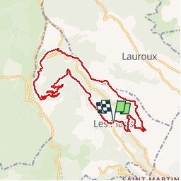

Length
18.7 km

Max alt
814 m

Uphill gradient
570 m
Km-Effort
26 km

Min alt
324 m

Downhill gradient
562 m
Boucle
Yes
Creation date :
2016-09-15 00:00:00.0
Updated on :
2016-09-15 00:00:00.0
5h45
Difficulty : Medium

FREE GPS app for hiking
 SityTrail
IGN / Geographical institutes
SityTrail Plus
The world is yours!
About
Trail Walking of 18.7 km to be discovered at Occitania, Hérault, Les Plans. This trail is proposed by JEANJOSY.
Positioning
Country:
France
Region :
Occitania
Department/Province :
Hérault
Municipality :
Les Plans
Location:
Unknown
Start:(Dec)
Start:(UTM)
522263 ; 4844614 (31T) N.
Comments